Location intelligence platforms allow users to analyze trends on maps and graphics to boost the performance of your business. They offer such features as density analysis, distance and travel data, and geospatial mapping to derive patterns and trends from the location data, as well as determine the terrain, etc.
Location intelligence platforms are your capable and effective solutions for dealing with any location-related issue, strategic planning, and making sure that all day-to-day operations help achieve your business goals.
In this article, I mentioned all the tools that do not need to be installed, and they either operate on the web or your PC. Some of them come with their own apps for iPhone and Android. As for prices, they are based on the functions a user is interested in and start from $25 per month.
Verdict: ArcGIS enables users to create, manage, analyze, and visualize GIS data with a great multitude of tools and features. This comprehensive Artificial Intelligence Software allows specialists to directly link data, conduct advanced analytics, and transfer results to third-party systems.
The platform comes with Map Creation, Location Tracking, Fixed Asset Management, Behavioral Analytics, and Paratransit Management options, and the range of its capabilities includes spatial analysis and data science, field operations, mapping, real-time visualization and analytics, 3D GIS, data collection and management, and more.
Although the service does not reveal prices for its services, it offers a 21-day trial version to test how well all its features perform to make an informed decision about whether it is worth a purchase.
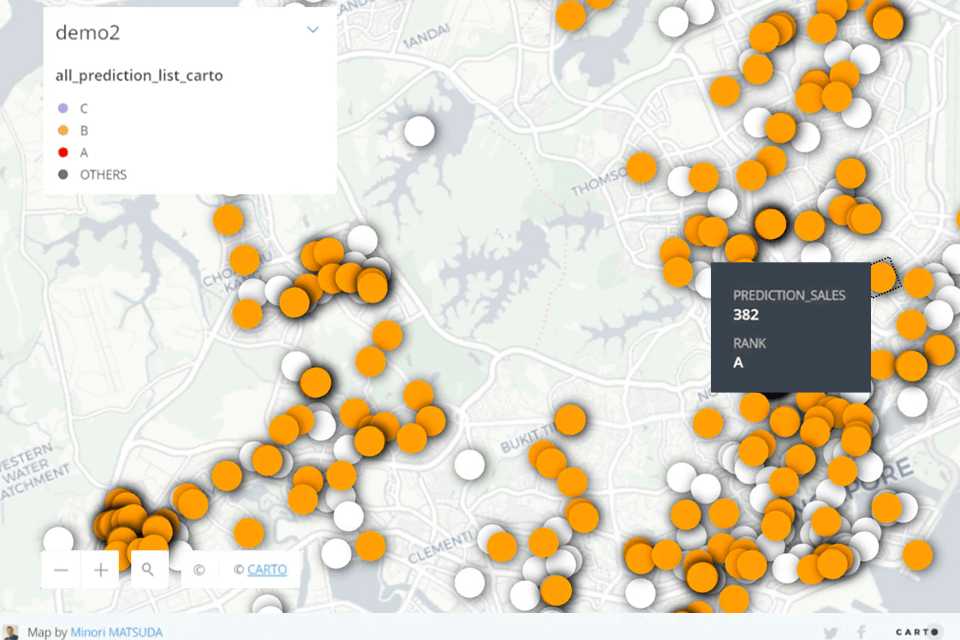
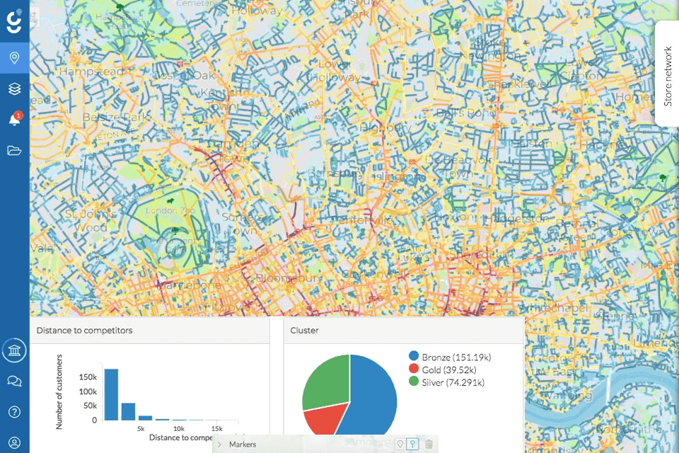
Verdict: Carto is a cloud-based comprehensive solution developed to meet the needs of marketing agencies, and startups. The platform supports Labeling, Demographic Data, and Spatial Analysis, and is an indispensable assistant for those who need to build maps and analyze trade areas.
With Carto’s spatial analysis tools, performing such tasks as buffering, overlay analysis, proximity analysis, and suitability modeling is a no-brainer. The system can also help you organize, store, and manage spatial data. Besides, the tool handles the data efficiently thanks to the extensive format support and databases.
As Carto offers APIs, it is easy to integrate location-based features into custom apps and workflows. It is to my taste that the platform has a two-week trial to test the system’s functionality. The price of an individual package is $199 per month, and if you are a company owner looking for an enterprise plan, contact the team to discover their offerings.
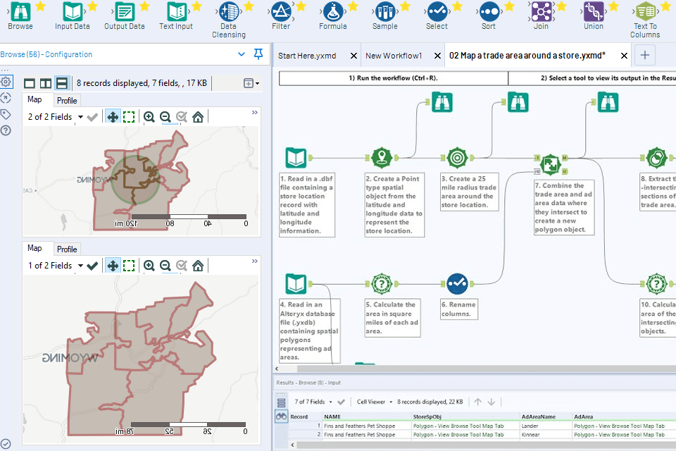
Verdict: Alteryx is a location based intelligence platform that uses ML technology to perform all the tasks automatically. Its toolkit is wide and includes location intelligence options to blend data, analyze, and visualize spatial data. With this self-service tool, you won’t have trouble mixing and cleaning data from various sources like spreadsheets, databases, and cloud services.
A user-friendly interface is another strength of the platform. It simplifies the performance of ELT processes for extracting and transforming data as required and exports it into the desired format or destination. There is also the ability to share reports and workflows with team members.
Alteryx works perfectly with all popular business intelligence tools and customer data platforms and databases to make the data analytics ecosystem more flexible.
Due to the large range of capabilities, the service is quite expensive. The cost of the cloud platform starts at $4,950. The desktop version will cost $5,195.

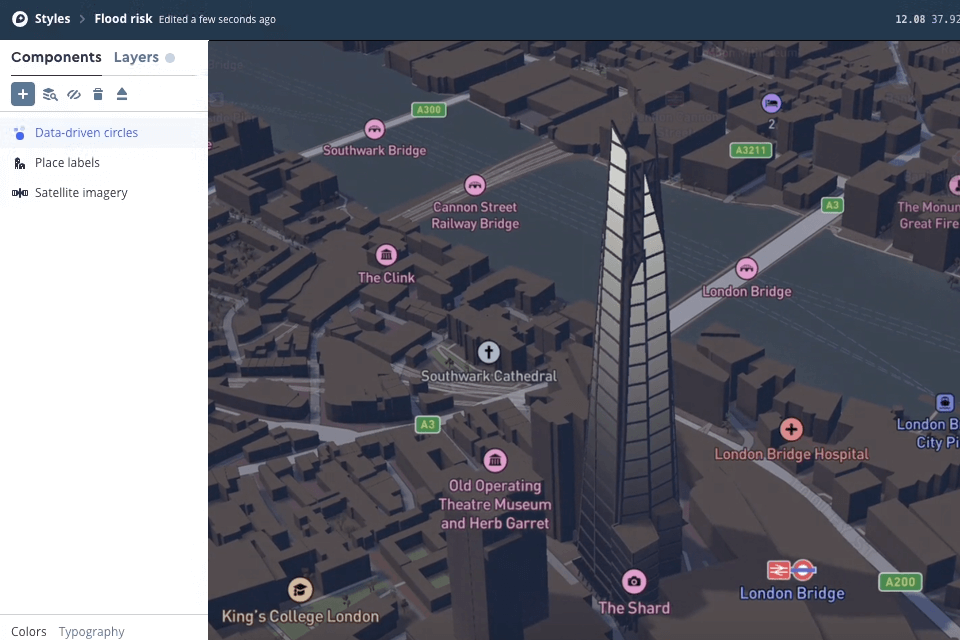
Verdict: Mapbox is your end-to-end solution for creating customizable maps that deliver navigation and location-based services for professionals who work on the development of mapping apps. Mapbox Studio works similarly to Photoshop but for editing maps. When it comes to the selection of visualization settings, the platform provides users with complete freedom.
Mapbox boasts cutting-edge routing engines, accurate, traffic-powered travel times, and intuitive turn-by-turn directions to provide users with a seamless navigation experience.
The Mapbox Vision SDK sees every location detail like a curb, lane, street sign, and road hazard as data providing a comprehensive picture. The developers won’t have trouble building navigation guidance, displaying driver assistance alerts, and detecting and mapping road incidents, as they can take advantage of the SDK's AI-powered semantic segmentation, object detection, and classification.
The price of the service is flexible and starts from $4 per month. You pay only for those functions that you need and use. Besides, the platform offers different discounts and accumulated bonuses.

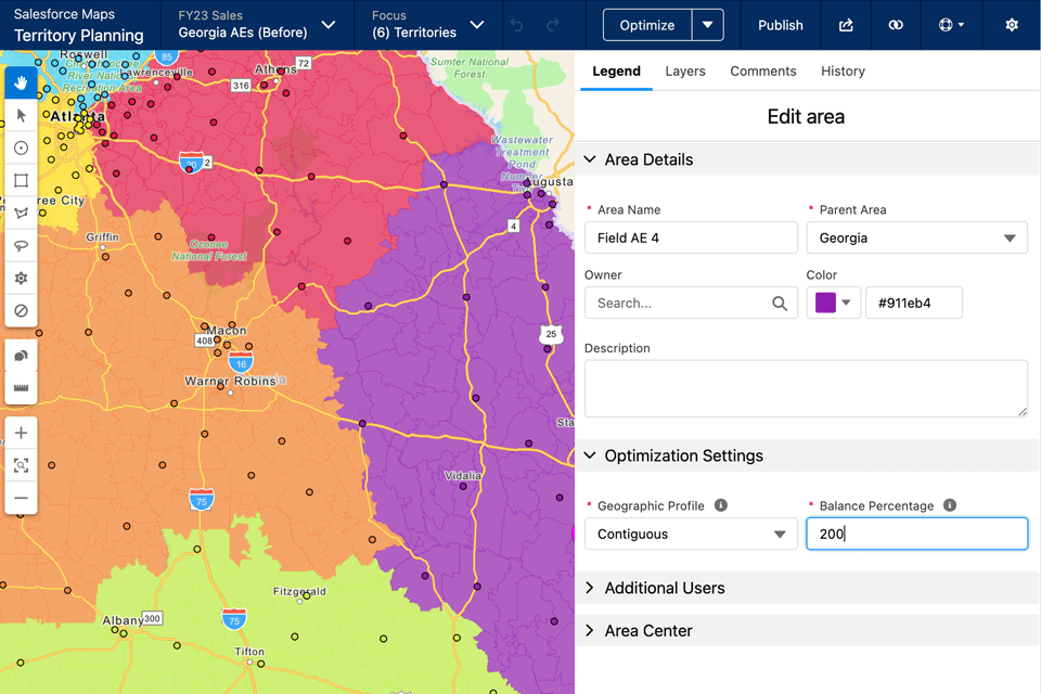
Verdict: Salesforce Maps is the best location intelligence software for sales and service teams that look for the most effective tools for creating the most optimal routes. With its help, it is easy to receive live updates from the industry. Of course, this solution is suitable for other use cases, but it is ideal for sales teams.
Data visualization, smart visits planning, and focusing on high-value leads and appointments are as easy as a pie when using Salesforce Maps. These options are perfect for companies that leverage the platform as their CRM.
An interesting feature of the platform is the ability to analyze potential clients based on attributes like Einstein score, potential revenue, or recency of the last activity. Therefore, you can use it along with popular sales engagement platforms.
There is a demo version for getting acquainted with the tool’s functionality. Afterward, you can choose from several packages the cost of which ranges from $25 per month to $300 per month for the user.

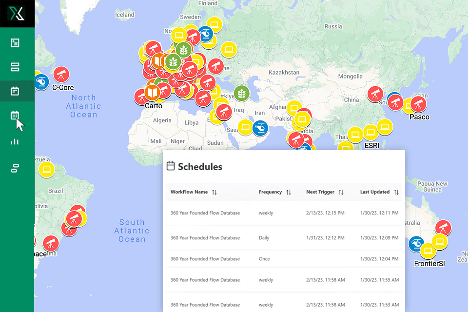
Verdict: Xtract.io uses RPA, AI, and other innovative technologies to speed up digital transformations. It boasts a collection of analytical tools including location intelligence data, online activity, and preferences. The platform will come in handy if you need to analyze football traffic and define the level of probability of entering a competitor store to convert more leads.
The platform also allows you to easily combine location data with data from other data analytics platforms, to better understand the needs of your customers. Statistics are updated every 30-60-90 days, which ensures highly accurate results.
Unfortunately, there is no trial period, but a demo version is available, after the end of which you’ll have to purchase a subscription.

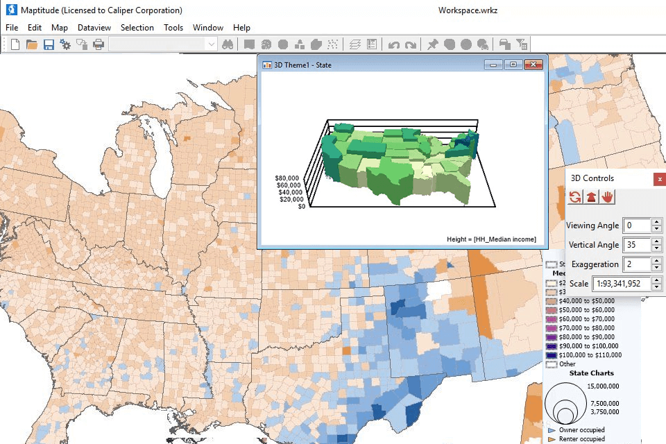
Verdict: Maptitude Geographic Information System (GIS) is one of the most popular location intelligence platforms that provide you with all the required tools, maps, and demographic data to get valuable insights about what influence geography has on your business.
MapWizard® automatic mapping technology allows mapping and visualizing your data to build maps that are easy to customize to your liking. You can change colors, styles, and labels.
The platform makes it possible to save cartographic analytical data in any convenient format, integrate it into other data visualization tools, or share it with partners online using Maptitude Online.
The cost of Maptitude starts at only $695. The plan also includes a free country package of GIS data that has everything you might require to take advantage of the power of location intelligence.

Verdict: Geoblink is your ideal solution for accumulating various types of data for better integration of internal data and its enrichment. It leverages ML-based techniques to analyze data. The platform integrates with a large number of services, which makes it possible to receive the most accurate and up-to-date information.
You can also integrate it with other real estate CRM or databases for convenient work.
The developers have not announced a fixed price for the platform, but they provide a free demo and trial version so that you can fully familiarize yourself with all the features of Geoblink. After getting acquainted, you can choose those functions that will be useful for your company and pay only for their use.

Verdict: GapMaps is a cloud-based location based intelligence platform that provides professional location intelligence, data analysis, location analytics, demographics, and mapping services. GapMaps is available as a Web App and an Android tool and works as a comprehensive solution.
There are tools that will allow you to analyze client behavior and visualize data in an easy-to-read format. It also includes features such as encoding, geofencing, location tracking, and even predictive analytics. The considerable advantage is that you can conduct trade area analysis in one place.
Besides, the system provides multiple login features that allow all members of your team to work on the platform at once. The cost of using the platform can only be found at the time of purchase because it directly depends on the functions you are going to use. However, you can test the platform’s functionality using a trial version before purchasing.

Verdict: Maptive is an advanced and user-friendly location intelligence platform that allows tweaking maps to your liking. You are to tweak the default opening view of the map and select from a great multitude of map styles. Users can share maps with individuals, post them on the web, as well as embed them within a webpage or blog with simple HTML code.
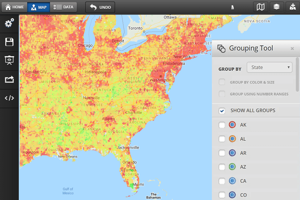
With precision level control, filtering data and optimizing the route between different places is an easy task. Maptive can become a handy assistant for businesses of all stripes providing them with drive time maps, heat maps, territory mapping tools, demographics, geographic boundary mapping, and data grouping, as well as customization of visualizations.
The cost of using the platform depends on the number of users and required functions and starts from $250/45 days. You can use the trial version to get acquainted with the program.