Those who need to create maps might benefit from using free map drawing software to save budget and complete their projects in no time. Such software will come especially in handy when you want to make a professionally looking business presentation, attract tourists to a particular area or illustrate an educational project.
Whether you want to design a map of your district or city, you will be able to work more effectively using pro-level tools. With their help, you can create a detailed map of any location.
On this list, there are the best free drawing software that can be used for creating different kinds of maps. You can draw up maps to illustrate geography, history, tourist locations, real estate, statistic data, etc.
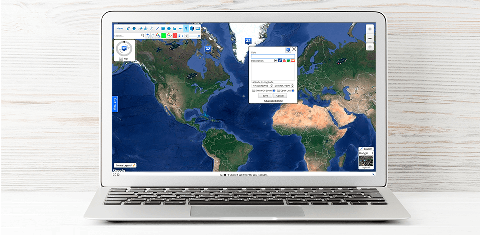
Verdict: Click2Map is a web-based map drawing program that is useful for those who want to create detailed maps for a wide variety of projects. As it meets the same standards as Google Maps, it’s compatible with many applications.
You can adjust all the tools to your liking, which allows you to give a free rein to your creativity. To add extra information, you can apply different markers. It’s also possible to draw borders, add lines and polygonal shapes to enhance selected areas.
Verdict: Mapme is a perfect option when a user needs to have a wide choice of features to choose from. It allows for designing interactive maps and can be considered one of the best free web design software. It will come in handy for real estate agents, virtual events’organizers and travel managers.
This map drawing app comes with a useful feature that allows you to see a list of the places that are worth visiting if you go to a certain area. It’s also possible to add pictures of different places, create 3D building layouts, add videos or PDF files that contain extra information.
Verdict: Scribble Maps is a program that creates maps and locations. This software tool is quite useful for drawing illustrative materials for lessons in different subjects.
All the maps can be customized with little to no effort. You can add extra information to enhance the usability of your maps. For instance, a travel agent can indicate tourist routes, landmarks, distances, while a history teacher can illustrate historical events.
It’s also possible to attach video and audio files. A user can save the final result as an image file or PDF. There is a native file format as well.
Verdict: This software product has been created specifically for business needs. If you work in a company, you can quickly indicate different routes or locations of certain buildings. This tool will be appreciated by those who create presentations as it has geo-positioning options.
The software is compatible with any device. It won’t take long to create a map by using the available tools. After opening ZeeMaps, you can create a new project, add any information that you need and save the file. There are also privacy settings that will be useful for those who work with sensitive data. The final result can be shared with coworkers and other people.
Thanks to the amazing choice of color-coding tools, you can make any location more visually distinct. This map drawing program allows for adding different files to your map, for instance, video clips, pictures, 3D objects, geo-location information.
Verdict: If you don’t need any advanced interactive features, take a look at this software. It is perfectly suitable for creating classical maps. By using it, you can draw any map you need, add text, indicate distance, draw borders, use lines and shapes to add extra information. It allows for embedding labels as well.
There is no need to have a Google account to use this map. You need just to go to the GmapGIS’s online platform and create a new project.
Verdict: Maptive has been designed with small businesses’ needs in mind as they will especially benefit from creating maps of particular locations. It also comes with a useful import option that allows for adding information from spreadsheets.
The interface is pretty simple and comes with all the necessary features for drawing up boundaries, indicating locations and routes. When a user enters the parameters, the software processes the data automatically.
Verdict: If you need to import data from different services, for instance, Google spreadsheets, Dropbox or Twitter, this software will significantly simplify your task.
Files can be imported in a ZIP format. Besides, Carto can open KML and KMZ files. This software saves all the data in a special form with tools that allow for adding new columns and editing styles.
Verdict: Map Chart can be deservedly called the best free graphic design software as it delivers quick performance and allows for creating pro-level maps that can be customized for any purpose. A user can create a map of a certain country, city or region. It’s also quite easy to draw a world map.
If you don’t need to see some locations, you can hide them from view. There is also a helpful zooming feature and a nice choice of patterns. Once your task has been completed, you can preview a map or save it in a PNG format.
Verdict: If you need to use software that is compatible with Windows, macOS and Linux devices, take a look at MapTiler. It comes with an impressive set of advanced features that have been appreciated by Google, NASA, Apple, as well as by other companies and institutions.
Those who work on creating maps based on geographical information will benefit from its professional tools. They allow for creating files compatible with Google Earth, Google Maps API mashups, MapQuest, Microsoft Bing and other services.
As this free map drawing software offers cloud storage space, you can view your maps online. With MapTiler, it doesn’t take much effort to add any objects, as well as import your pre-saved data to improve your map.
Verdict: If you don’t want to be bothered with products that offer limited sets of tools, make sure to consider this professional software for heat maps creation.
Heatmap Tool can process a lot of information and create stunning visualizations. For example, it can use CSV files for drawing up highly detailed maps. Then, you can customize your project by choosing colors, setting its size and adding extra information.
Thanks to the scaling feature, it will be quite easy to view your map. Another advantage is an option that allows for adjusting the temperature by making some areas dimmer. For better clarity, you can make the edges of high-temperature areas either sharp or blurred.